| Home | > | List of locations | > | Nkhotakota Game Reserve |
Location: Nkhotakota Game Reserve
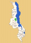
Photo: Bart Wursten
Map showing location of Nkhotakota Game Reserve
General Information
Quarter degree square: 1234C1, 1234C3, 1233D2, 1233D4 & 1333B2 Country: Malawi Habitat: Miombo woodland, rocky habitats, evergreen forest and riverine vegetationr Altitude range: 575 - 1150 m Annual rainfall: Location (short): Location (detailed): Nkhotakota Game Reserve covers an area of 1,800 km² and is situated inland and West of Nkhotakota town. |
Description
The reserve is has only been managed by an NGO since 2015 and is in the process of being rehabilitated after long periods of heavy poaching. It consists of rugged terrain crossed by several rivers making their way from the escarpment in the West to Lake Malawi further towards the East. Most of the reserve is miombo woodland with large patches of tall grasses and occasional areas of evergreen forest.
For more information see Wikipedia.
Useful links
View a list of records for Nkhotakota Game Reserve
View a list of unique taxa (excluding cultivated plants) for Nkhotakota Game Reserve
View a list of unique taxa (all taxa whether cultivated or not) for Nkhotakota Game Reserve
View a list of recorders who have visited this location
| Home | > | List of locations | > | Nkhotakota Game Reserve |